FAQ: WHAT IS UTM-UPS?
(4 July 1998 -UTM)
(15 June 2007 -Add UPS)
UTM
UTM, Universal Transverse Mercator, is a system of
world coordinates like latitude and longitude, from 80 degrees south latitude
to 84 degrees north latitude, except the measurements are in meters and
UTM lines are orthogonal (always at right-angles to each other).
This projection makes all latitude and longitude lines (except the central
meridians) curved.
Unlike the regular Mercator, "Transverse Mercator" is a projection
with the cylinders rotated 90 Deg (to east-west) and touch the earth "universally"
at 60 "central meridian" longitudes. Coordinates are "UTM northing" and
"UTM easting."
UTM Northing is the distance north from the equator in meters and
Easting is the distance east from 60 central meridians of 6-degree-wide
zones starting at longitude 180 degrees.
UTM Northing is divided into 8-degree-high zones from 80 Deg. south
latitude to 84 Deg. north latitude using the letters C thru X with the
equator at M/N. A,B and Y,Z are reserved for the UPS coordinate system
at the poles. For a map of UTM zones see (HERE).
All UTM coordinates are POSITIVE by incorporating a system of "false"
easting and northing. Adding an arbitrary 500,000m to the central
meridians and subtracting the distance south of the equator from 10,000,000m
in the southern hemisphere keeps all readings positive.
The UTM map scale increases to either side of the central meridian,
so the scale is reduced to 0.9996. This way there will be two meridians
to either side of the central meridian where the scale will be correct
which improves the average map scale accuracy.
The original definition of the meter was 1/10,000,000th the distance
from the equator to the north pole (which is no longer exact.) Due
to the oblate shape of the earth, UTM (WGS-84 datum) northing for 45 Deg.
N latitude is 4,986,272m instead of 5,000,000m. For UTM (NAD-27 datum)
the northing value is 4,986,055m.
This 217m difference is related to the UTM northing errors of approximately
200m experienced by posters here on the NG with some DRG maps. This
is due the program, GPS, or user selecting the wrong datum.
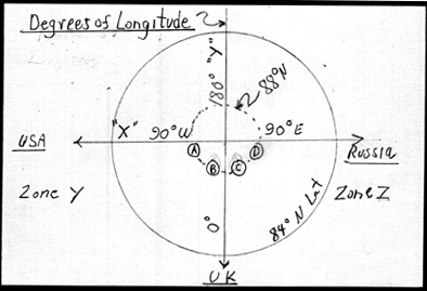
UPS
THE UNIVERSAL POLAR STEREOGRAPHIC (UPS) SYSTEM coordinates are based
on a family of two Polar Stereographic map projections, one for each pole.
The UPS system is defined above 84 degrees north latitude and south of
80 degrees south latitude. The origin of the UPS coordinate system
are the poles (north or south), where both the X and Y coordinate values
are 2,000,000m.
The X-axis lies along the meridians 90°E and 90°W. Moving
from the pole (north or south), X-values (Eastings) increase along the
90°E meridian and decrease along the 90°W meridian.
The Y-axis lies along the meridians 0° and 180°. Moving
from the north pole, Y-values (Northings) increase along the 180° meridian
and decrease along the 0° meridian.
(Now don't confuse the "X" and "Y" Axis' with the Zones!!)
Zone Y is the Western Hemisphere. Zone Z is the Eastern hemisphere.
With the unit set to a Position Format
of UTM UPS,
At the North Pole both Easting and
Northing are 2,000,000m
(NOTES: The unit will convert from UTM to UPS automatically
when traveling northward.
WAAS should be turned OFF, since there are no SBAS
corrections at either pole.)
Examples of What a Garmin
GPS will Display (In a walk around the North Pole) in UPS Meters
Waypoint:
(A) (B)
(C) (D)
Location:
N88° W089° N88° W001°
N88° E001° N88° E089°
GPS Readouts
(X Axis, Easting) Y 1777952
Y 1996124 Z 2003876
Z 2222048
(Y Axis, Northing) UTM 1996124
UTM 1777952 UTM 1777952 UTM 1996124
Get these waypoints (HERE)
Jack
Yeazel